Top Hikes At Mt. Baker
Mt. Baker is home to some of the most beautiful hikes you'll find!


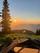
-Ptarmigan ridge: Distance: 9 miles roundtrip. Elevation gain: 1800 feet. Road is accessible to all cars (paved road and parking).
A beautiful hike with views starting in the beginning. It’s also not a very hard hike since the elevation gain is minimal over the course of 4.5 miles (one way). This is also a very popular hike during the summer (especially in August) so be prepared for that.
Best time to hike: Mid July to late September if you want to go when it’s snow free.

-Table mountain: Distance: 2.6 miles roundtrip. Elevation gain: 725 feet. Road is accessible to all cars (same parking lot as Ptarmigan Ridge).
An easy hike with great views that doesn’t include a lot of elevation gain. You park at artist point and you’ll see the trail right next to ptarmigan ridge.

-Excelsior peak: Distance: about 8 miles roundtrip. Elevation gain: 3,600 feet.
With the parking lot being right off the highway, this hike is accessible for any car. It starts with a pretty rigorous and steep trail that doesn’t seem to flatten at all. It’s a tough hike that starts in the forest but once you make it to the top you’ll feel accomplished and have a great lunch view. Best time to hike: I’d say this hike is accessible almost year round. Because you start at a lower elevation, there’s almost never snow at the trailhead and once you hit the snow, you’re transported into a winter wonderland and it’s just so magical!

I have to start out by saying the drive up to the trailhead is HORRIBLE. Once you turn off from the highway, it’s 12 miles of massive potholes and big rocks. This is one of the worst drives up to a trailhead you’ll find (Twin lakes/Winchester mountain ties with this). Be sure to have a high clearance vehicle and give yourself about 45 minutes to an hour to make it up to the trailhead. And yet, it’s still one of the most popular hikes by Mt. Baker. But I can see why! Although it starts out hard and steep, once you make it out of the switchbacks and into the opening, it’s beautiful! You have a great view of Baker, the Twin Sisters, and the surrounding mountains. And the wildflowers are gorgeous here! It’s also a popular overnight hike with sunrise and sunset views. Just make sure you bring heavy duty bug spray. The mosquitos and flies have no mercy and attack at every opportunity they have.

-Heliotrope ridge: Distance: 5.5 miles roundtrip. Elevation gain: 1,400 feet. The road and parking lot is paved so any car can make it up!
Such a great hike! It’s a shorter and easier trail and the views you get from it are incredible! You’re right next to Baker and have a close up view of the glaciers and crevasses. It’s a great hike to enjoy the wildflowers in the summer and the blueberries in the fall.

This is one of the longer hikes by Baker so I would plan on spending the day here. The first couple miles of the hike is more of a walk with very little elevation gain. Then the switchbacks and the climb up begins. But the good news is that you have fantastic views almost from the beginning of the hike. And once you make it to the peak, you’ll have 360 views which includes Baker, Ruth mountain, and British Columbia.

This is a tough but rewarding hike! It starts out steep in the forest with about 12 switchbacks before it evens out for a bit. Then the climb continues but the trail opens up and you start to see some great views. Once at the top, you’ll see Baker, Shuksan, and Mounts Sefrit. And if you still have any energy left you can continue on an unofficial trail up another .8 miles and 1,000 feet. This will put you at a height of 6,600 feet.

Another difficult hike! With a lot of elevation gain, this may not be the hike for everyone. It starts out with a lot of switchbacks and after that there’s more switchbacks. However, once you make it to the meadow you’ll be glad you pushed yourself! With beautiful views of Baker and plenty of blueberries in the fall, this would be a great stopping point. But you’re not a wuss, so you continue up the final stretch that’s (no surprise) steep going up to the peak. From here, you’re rewarded with 360 views and a sense of accomplishment.

To fully experience the beauty of this hike, I’d recommend going in the Fall time. With all the changing colors and delicious blueberries, this hike has a lot to offer. However, it is a popular one so I’d suggest going during the week early morning or late afternoon.
The trail starts out steep for the first 1.5 miles with an elevation gain of about 1,500 feet. After this it mellows out a bit until the finish push to the peak. Once at the top, you’ll enjoy 360 views of Baker, Shuksan, Tomyhoi, and other peaks.

Let me start by saying the drive up is the worst I’ve experienced. Almost to the point where I question if it’s even worth it. This is the same road that goes up to Yellow Aster Butte, however the trailhead to Winchester is another 2 miles up. And it’s these 2 miles that are treacherous. Don’t eat before the drive up because you’ll probably throw up from all the bouncing. The road is mostly very narrow with drop offs, huge rocks, and even bigger potholes.
With all that being said, this continues to be such a popular hike. The reason why is because it’s a short and easy hike with great views of the surrounding mountains and twin lakes. Not to mention that you’ll be at an elevation of 6,521 feet. Not bad for such minimal effort.


Comments
Post a Comment